Pursuant to 16 U.S.C. § 551 and 36 C.F.R. § 261.50(a), and to protect natural resources, the following acts are prohibited within the Lake Tahoe Basin Management Unit. This Order is effective from June 27, 2021, through June 27, 2024.
Camping, except in the areas described on Exhibit A for no more than 14 days in a calendar year in total, as shown on Exhibit 36 C.F.R. § 261.58(e).
Building, maintaining, attending or using a fire, campfire, or stove fire, except within the areas listed on Exhibit B. 36 C.F.R. § 261.52(a).
Pursuant to 36 C.F.R. § 261.50(e), the following persons are exempt from this Order:
Persons with Forest Service Permit No. FS-7700-48 (Permit for Use of Roads, Trails, or Areas Restricted by Regulation or Order), specifically exempting them from this Order.
Persons with a valid California Campfire Permit are not exempt from the prohibitions listed above, however, persons with a valid California campfire permit may use a portable campfire pit, stove, or lantern that uses gas, kerosene, jellied petroleum or pressurized liquid fuel.
Any Federal, State or local officer, or member of an organization rescue or fire fighting force in the performance of an official duty.
These prohibitions are in addition to the general prohibitions found in 36 C.F.R. § Part 261, Subpart A.
A violation of these prohibitions is punishable by a fine of not more than $5,000 for an individual or $10,000 for an organization, or imprisonment for not more than six months, or both.
16 U.S.C. § 551 and 18 U.S.C. §§ 3559, 3571, and 3581.
Done at South Lake Tahoe, California, this 24th day of June, 2021.
_____________________________
Gwen Sanchez
Acting Forest Supervisor
Exhibit A
Lake Tahoe Basin Management Unit
Camp Richardson Resort and Campground
Fallen Leaf Campground
Bayview Campground
Meeks Bay Campground
Meeks Bay Resort
Within 300 feet of the McKinney-Rubicon Springs Road (Forest Road No. 14N34), from its intersection with the Off-Highway Vehicle Staging Area, then west to its intersection with the boundary of the Tahoe National Forest.
Buck Lake
Kaspian Campground
Blackwood Canyon Campground
Watson Lake Campground
Within 300 feet of the Tahoe Rim Trail.
Within 300 feet of the Pacific Crest National Scenic Trail, from its intersection with the southern boundary of the Lake Tahoe Basin Management Unit, then north to its intersection with the northern boundary of the Lake Tahoe Basin Management Unit.
Zephyr Cove Campground
Nevada Beach Campground
Luther Campground
Meiss Management Area
Mount Rose Wilderness
Within 300 feet of Genoa Peak Road (Forest Road No. 14N32), from its intersection with White Hill Spur Road (Forest Road No. 14N32A), then south to its second intersection with Logan House Loop Road (Forest Road No.14N33).
William Kent Campground
Within the Desolation Wilderness with a valid Wilderness Permit.
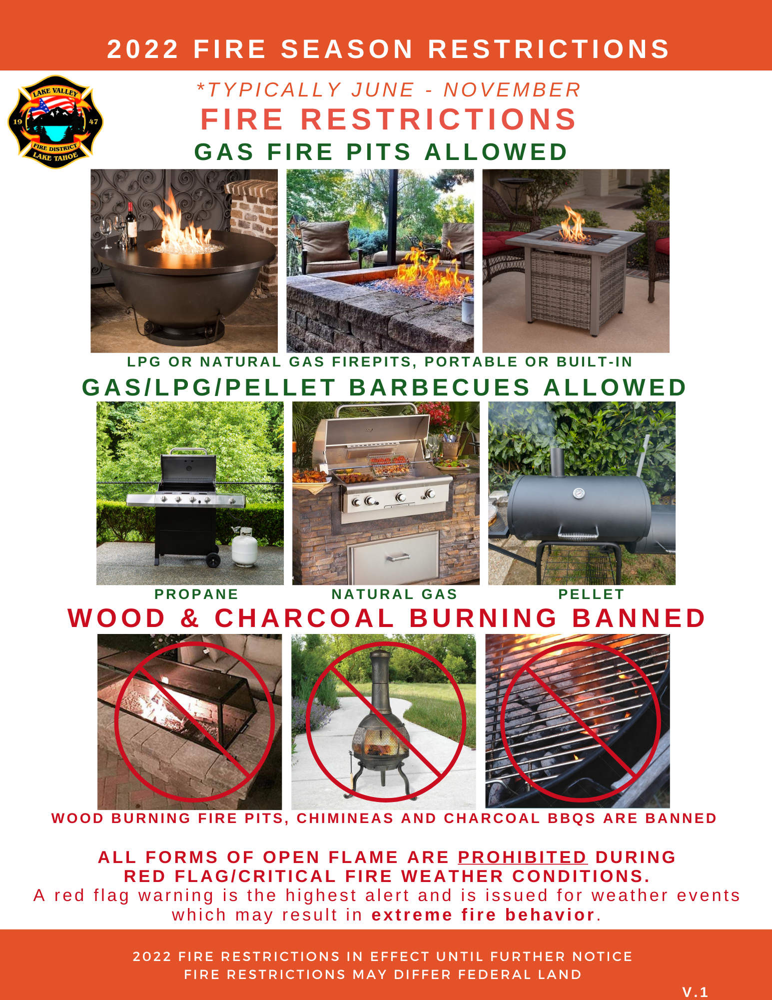
The Lake Valley Fire Protection District has activated local fire restrictions and has suspended the outdoor burning of solid fuels as of June 1, 2022. ONLY Natural Gas (NG) or Propane (LPG) outdoor fire pits and barbecues, and pellet grills/smokers are allowed. The ban remains in effect for the duration of the fire season.
Enjoy your Tahoe summer safely with family and friends and BE FIRE SAFE. For more information, contact us at (530) 577-3737.
Many hazards exist including fire-weakened trees, burned stump holes and missing trail signs
SOUTH LAKE TAHOE, Calif., March 31, 2022 – The USDA Forest Service Lake Tahoe Basin Management Unit (LTBMU) reminds recreationists to use caution when recreating in the 2021 Caldor Fire area. Residents and visitors should be aware of their surroundings and use common sense when recreating in the burn area. Burned landscapes present numerous safety hazards for recreationists that either did not exist prior to the fire or have been worsened by the effects of the fire.
“Risks to those choosing to recreate in the Caldor Fire burn area will continue to evolve over the next several years,” said Public Services Staff Officer, Daniel Cressy. “Always practice responsible recreation and be aware of your surroundings including wind and other weather conditions, which can weaken fire-damaged trees.”
No area closures are in currently place on the LTBMU. All trailheads and trails in the burned area are open, however multiple hazards may exist. Hikers, mountain bikers and others venturing into the burn area should be prepared to navigate without visible trails or trail signs and be sure to bring along a map, GPS app or device. Practice good stewardship by staying on trails because without live plant roots to anchor the soil, burned soil can easily be worn away.
In addition, please keep the following in mind:
Flash Floods/Debris Flows: Fast-moving, highly destructive flash floods and debris flows triggered by intense rainfall are one of the most dangerous post-fire hazards. The risk of floods and debris flows after a wildfire increases due to vegetation loss and soil exposure. Always avoid recreating in post-fire areas during rain events. If caught unaware, move to high ground. Never attempt to drive or hike through an area that has been flooded or if debris flows have occurred. These types of events hide dips in roads or trails and other obstacles. Worse still, there may not be a road or trail at all. Flooding and debris flows can wash away entire roads or trail surfaces and a significant amount of ground underneath.
Damaged or Dead Trees: After a wildfire, many trees are weakened from burning around the base of the trunk. These trees can fall over, blow down, or drop limbs without warning. Shallow-rooted trees can also fall. Therefore, always be extremely alert when recreating around burned trees, especially after rain events or during high winds. Never picnic, camp, or park a vehicle close to dead trees. Look up while on trails and if the wind kicks up, head to a clearing out of reach of any potential falling trees.
Burned Stump Holes/Root Chambers: Burned stumps may create obvious large holes, but these holes may be bigger than they appear. In many cases, the fire may have traveled through root chambers and consumed the woody root material leaving hollow spaces where solid wood used to be. Overtime, these root chambers will collapse. A person’s body, mountain bike or vehicle weight may cause these chambers to collapse, potentially opening a hole. Large trees have particularly big root chambers that can be very deep. Be especially wary after rain events as the moisture may travel through the root chambers and make collapse easier.
For additional information on the LTBMU, please visit our website or follow us on Facebook and/or Twitter.
For information about open and closed Caldor Fire areas on the Eldorado National Forest, visit their website.