by Martin Goldberg | Nov 17, 2025 | News, Uncategorized

South Tahoe Public Utility District (STPUD) and Lake Valley Fire Protection District (LVFPD) have started an update of their Multi-Jurisdictional Hazard Mitigation Plan. The plan will develop near-term and long-term mitigation actions that reduce risk from drought, floods, winter storms, wildfires, and other natural hazards.
“Community input is essential to set priorities and identify projects,” said Megan Colvey, Director of Engineering with STPUD.
Hazard mitigation means taking actions that reduce or eliminate long-term risk to people, property, infrastructure, the economy, and the environment.
“Planning before a disaster helps us prioritize safety and protect our community,” said Colvey.
National studies show communities gain strong value from mitigation investments, with significant savings for every dollar spent. A plan that is updated every five years, also keeps the
STPUD and LVFPD eligible for state and Federal Emergency Management Agency (FEMA) Hazard Mitigation Assistance grant funding.
The update will follow FEMA guidance through a four-phase, nine-step planning process during 2025 and 2026. A Hazard Mitigation Planning Committee will help steer the work and ensure
broad participation by residents, businesses, partner agencies, and community organizations.
How to participate
Take the public survey (Click here) to share your experience with local hazards and ideas for risk reduction. The survey is available in English and Spanish and remains open through
November 30, 2025.
Attend the Public Workshop in 2026 once the draft Plan is ready for review.
Stay updated by visiting: www.stpud.us/hazard-mitigation-plan-update
Benefits to the community include protecting public safety, reducing damage to existing and future development, hardening critical water and wastewater infrastructure, and minimizing service disruptions. STPUD and LVFPD will use community input to identify and prioritize a portfolio of mitigation actions.
“We encourage everyone on the south shore to take a few minutes to complete this survey to help your water/sewer and fire districts understand your concerns,” said Colvey.
If you have questions, call STPUD at (530) 544-6474 or email info@stpud.us. For Lake Valley Fire Protection District questions, contact us at (530) 725-9499 or email
by Martin Goldberg | Sep 30, 2024 | News
Lake Valley Fire Protection District Notice of Vacancy and Intent to Appoint Director
The community served by the Lake Valley Fire Protection District (LVFPD) is hereby notified pursuant to Government Code §1780 that there is a vacancy on the Lake Valley Fire Protection District Board due to the resignation of a Board Member. The appointee will represent the community served by the Lake Valley Fire Protection District as a Board Director. The position to be filled is a 4-year term beginning December 2024 and ending December 2028.
To apply, candidates must submit a letter of intent along with a current resume to the Lake Valley Fire Protection District at 2211 Keetak St, South Lake Tahoe, CA 96150, attention Chad Stephen by Friday, November 1, 2024 by 5:00 PM.
Eligibility:
Any person who is 18 years of age or older, a registered voter and resident of the Lake Valley Fire Protection District, and who is not disqualified by the Constitution or laws of the state from holding office, is eligible to be appointed a member of the Board of Directors.
Interviews:
The Board of Directors will interview prospective candidates on at the special board meeting to be held Thursday, November 7, 2024 at 4:00, and will accept oral or written public input at that time, and select the appointee by a majority vote.
by Martin Goldberg | Sep 18, 2024 | News
(Lake Tahoe, CA and NV) – A new Lake Tahoe Regional Evacuation Plan was developed by the cooperative efforts of the Lake Tahoe Fire Chiefs, Lake Tahoe Law Enforcement Agencies, and Emergency Management Personnel following experiences gained during past major wildfires. The Plan is a “living document” intended to provide the public with critical information related to evacuations and will be updated from time to time.
The Plan pulled together a diverse team of experts from two different states and five different counties which all have jurisdictional responsibilities around Lake Tahoe. The efforts resulted in a robust and critically needed Regional Evacuation Plan.
The plan is currently located at: laketahoeregionalevacuationplan.pdf (ca.gov). The plan is organized so that the evacuation information in the front of the plan is applicable to ALL parts of the Lake Tahoe Basin. Then there are seven annexes in the back of the plan that allows for more specific information which is only pertinent to the specific areas.
The Plan emphasizes regional cooperation and collaboration in event of a large wildfire that may occur in the future. Local emergency experts recognize that planning for a large wildfire that will require evacuations is a reality for the Tahoe Basin. Fire, Law, and Emergency Management partners are more prepared to manage these events as a result of this new Plan.
The Plan is a “living document” and is open for a sixty-day comment period ending on November 20, 2024. Submit your comments by emailing Captain Martin Goldberg at goldberg@lakevalleyfire.org.
by Martin Goldberg | Jul 1, 2024 | News
Notice of Consolidated Districts Election will be held on
Tuesday November 5, 2024
Three Full Terms to be elected will expire 12/06/2024 (Incumbents) John Rice, Leona Allen and (Appointed) Tim Cain
The community served by the Lake Valley Fire Protection District (LVFPD) is hereby notified pursuant to California Code, Election Code §12112 that there are three (3) open seats on the Lake Valley Fire Protection District Board due to the expiration of current member seats on 12/06/2024. The elected will represent the community served by the Lake Valley Fire Protection District as a Board Director. The position to be filled is a 4-year term beginning December 2024 and ending December 2028.
Declaration of candidacy forms for eligible candidates desiring to file for any of the elective offices may be obtained from the Elections Department at 3883 Ponderosa Road, Shingle Springs, CA. Forms shall be available commencing on July 15, 2024, before the election, and shall be filed with the Elections Department, in person no later than 5:00 p.m, August 9, 2024, before the election.
For more information, visit https://www.eldoradocounty.ca.gov/County-Government/Elections or call (530) 621-7490. You may also contact Fire Chief Chad Stephen by email at stephen@lakevalleyfire.org or call (530) 577-3737 Ext 6.
Eligibility:
Any person who is 18 years of age or older, a registered voter and resident of the Lake Valley Fire Protection District, and who is not disqualified by the Constitution or laws of the state from holding office, is eligible to be appointed a member of the Board of Directors.
by Martin Goldberg | Jun 17, 2024 | News
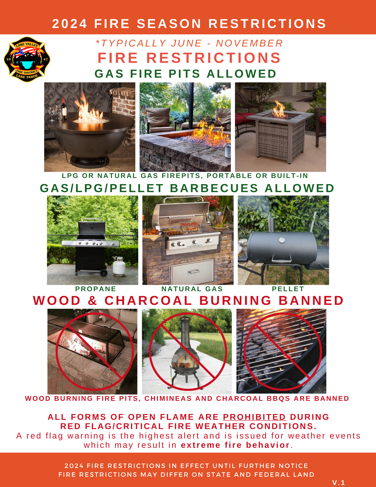
The State of California suspended Burn Permits in Alpine, Amador, El Dorado, Eastern Sacramento, and North-Eastern San Joaquin Counties as June 17, 2024. Per Lake Valley Fire local ordinance No. 2022-01, the District prohibits open burning on all lands within the District boundaries within 24 hours of the State restrictions.
Please see Ordinance Section 307.4.4 “Open Burning Restrictions” and Section 202 “Definition of Open Burning”.
Section 307.4.4 Open Burning Restrictions. Open burning on all lands within the jurisdiction of the LAKE VALLEY FIRE PROTECTION DISTRICT (LVFPD), including the Local Response Area (LRA), is prohibited when the California Department of Forestry and Fire Protection (Cal Fire) issues a burn suspension in the State Responsibility Area (SRA). This prohibition shall be made effective 24-hours following its commencement in the SRA.
Open burning is also prohibited on all lands within the jurisdiction of LVFPD at any time the fire code official that atmospheric conditions or other local circumstances make such fires hazardous, including factors such as high winds, low fuel moisture, fire weather, the issuance of red flag warnings, the severe threat of wildland fire, or present risk of destruction by wildfire to life, wildlife, property, or natural resources.
SECTION 202 “OPEN BURNING”
OPEN BURNING. The burning of materials wherein products of combustion are emitted directly into the ambient air without passing through a stack or chimney from an enclosed chamber. Open burning does not include road flares, smudge-pots and similar devices associated with safety or occupational uses typically considered open flames. For the purpose of this definition, a chamber shall be regarded as enclosed when, during the time combustion occurs, only apertures, ducts, stacks, flues or chimneys necessary to provide combustion air and permit the escape of exhaust gas are open.
Open burning shall also include campfires, bonfires, portable outdoor fireplaces, ceremonial fires, and recreational fire as defined in the Fire Code.
Exception:
- UL or ASMI listed LPG or natural gas outdoor flame devices, such as gas BBQ’s or gas fire pits that comply with the Fire Code.
- For one-or two-family dwellings, fixed or portable outdoor flame devices that meet the following:
- Devices shall comply with the Fire Code.
- Devices shall be used per the manufacturer’s specifications.
- Minimum 10-foot clearance from device to all flammable material and vegetation.
- No burning shall be conducted during high or extreme fire weather conditions (e.g., National Weather Service Red Flag Warnings).
- Campfires on private lands. Where required by the fire code official, a permit shall be issued by the fire code official.
- Ceremonial and/or religious burning with the following safety measures:
-
- Maximum 4-foot x 4-foot burn area.
- Minimum 10-foot clearance from the edge of the burn area to all flammable material and vegetation.
- An approved water supply is located within 500 feet of the burn area.
- The burn area is located no less than 30 feet from adjoining property lines.
- An adult is present with a shovel until the fire is extinguished.
- No burning shall be conducted during high or extreme fire weather conditions (e.g., National Weather Service Red Flag Warnings).