by Martin Goldberg | Aug 15, 2022 | News

The Key to Evacuating Quickly and Safely is Preparation
Contact: Jamie Roice-Gomes, Living With Fire Program Manager [email protected]
As record drought and elevated wildfire conditions persist, the Tahoe Fire and Fuels Team (TFFT) reminds residents and visitors to develop an evacuation plan for your family and pack a Go-Bag before the next wildfire.
Emergency responders follow carefully designed evacuation plans that consider all factors when implementing evacuation orders. When asked to leave, it’s crucial to evacuate quickly and safely — preparing for evacuation ahead of time is the best way to ensure a safe, successful evacuation. One way to prepare is to pack a Go-Bag.
“When it comes to evacuation, planning ahead is always a good idea,” said Fire Marshal, Eric Guevin, from Tahoe Douglas Fire Protection District. “Be prepared to act fast because time matters, and it could be a matter of life and death or loss of property.”
Choose a Go-Bag(s) that can be easily lifted into your vehicle and has room for necessary items to last a minimum of 72 hours up to two weeks. Rolling suitcases, backpacks and cloth shopping bags are good choices. Once packed, practice loading the Go-Bags into your vehicle and drive potential evacuation routes with family and pets to ensure you’re prepared and able to evacuate quickly.
Some items to pack into evacuation Go-Bags include:
- Enough medication for a minimum of 72 hours up to two weeks
- Lists of prescriptions and their dosages, prescription numbers, medication names, prescribing physicians, and pharmacy names and contact information
- Bottled water for a minimum of 72 hours up to two weeks
- Non-perishable foods that don’t require preparation or refrigeration such as nuts, trail bars, jerky, and cereal
- NIOSH N95 or P100 masks for wildfire smoke
- Important documents
- Cell phone chargers
- Supplies, water, food and medications for pets, including pet carrier(s)
For a more comprehensive list and helpful ways to prepare for the next wildfire evacuation, please visit https://www.tahoelivingwithfire.com/ and view the Wildfire Evacuation Checklist or the Wildfire Evacuation Checklist in Spanish, Instrucciones Para Evacuar En Caso De Incendios Forestales.
About the Tahoe Fire and Fuels Team
The Tahoe Fire and Fuels Team (TFFT) consists of representatives of Tahoe Basin fire agencies, CAL FIRE, Nevada Division of Forestry and related state agencies, University of California and Nevada Cooperative Extensions, the Tahoe Regional Planning Agency, the USDA Forest Service, conservation districts from both states, the California Tahoe Conservancy, and the Lahontan Regional Water Quality Control Board. Our Mission is to protect lives, property and the environment within the Lake Tahoe Basin from wildfire by implementing prioritized fuels reduction projects and engaging the public in becoming a Fire Adapted Community.
For more information, visit https://www.tahoelivingwithfire.com/
by Martin Goldberg | Jul 31, 2022 | News
Tahoe Fire and Fuels Team
Agencies share simple tree removal and defensible space steps in urgent call to action
Contact: Jeff Cowen, Tahoe Regional Planning Agency, (775) 589-5278 or [email protected]
LAKE TAHOE, Calif./Nev., July 20, 2022 – With smoke in the air again, the Tahoe Fire and Fuels Team and Tahoe Regional Planning Agency (TRPA) are sharing an urgent call to action for Lake Tahoe residents and property owners to create defensible space and to follow a few simple steps if tree removal is needed.
Fire agencies, TRPA, and other water quality agencies are in agreement on all defensible space requirements and have developed simple tree removal guidelines to
aid property owners in protecting homes and neighborhoods.
Defensible space is the area between a house and an oncoming wildfire where the vegetation has been managed to reduce the wildfire threat. Creating this space allows firefighters to safely defend the house and could even improve the likelihood of the home surviving without assistance. TFFT Incident Commander and North Lake Tahoe Fire Protection District Division Chief Isaac Powning says while defensible space sometimes requires a little planning, it should be a top priority for residents. “Start with the simple things like raking pine needles and moving firewood away from structures,” Powning said. “Getting a free defensible space evaluation from your local fire agency will tell you what is needed, then it’s a matter of breaking it up into manageable projects. Tree removal may be a part of it, but the other recommendations are just as important.”
Following the 3,100-acre Angora Fire in 2007, forest managers, fire agencies, and water quality agencies including TRPA formed the Tahoe Fire and Fuels Team to coordinate efforts, streamline policies, and increase the pace and scale of forest health projects. The improved coordination led to some of the preparations that helped firefighters protect Lake Tahoe communities last year when the Caldor Fire entered the basin and burned nearly 10,000 acres.
“Property owners have a critical part to play in creating more resilient forests and protecting communities and TRPA encourages everyone to follow defensible space
guidelines,” TRPA Public Information Officer Jeff Cowen said. “Public agencies are in alignment and working together to prevent and prepare for wildfires and protect the natural resources we all treasure at Tahoe.” Most fire hazard trees and limbs can be removed without a permit. Trees more than 14
inches in diameter and trees in a few specific circumstances require a Tahoe Regional Planning Agency permit, which is usually available from the local fire protection district with a defensible space evaluation.
Here is what property owners can do without contacting a permitting agency:
Remove and manage brush in the “lean, clean, and green” zone within 30 feet of
structures. Brush and smaller trees are ladder fuels, which can carry flames
upward from the ground and into the tree canopy.
Remove dead limbs, limbs within 10 feet of a chimney outlet, building or deck,
and any live limbs in the lower one-third of the tree.
Remove live trees less than 14 inches diameter at breast height. Diameter at
breast height is measured 4.5 feet above ground on the uphill side of the tree. If
unsure, use a string or soft measuring tape to measure around the tree. A 14-
inch tree is 43.9 inches around.
Remove dead trees. A conifer (pine/fir tree) is considered dead when it doesn’t
have any green needles. Deciduous (leafy) trees can be determined dead by a
qualified forester.
Outside of these circumstances, the first step is to request a free defensible space evaluation from the local fire district or department. In most cases, defensible space evaluators can issue tree permits on behalf of the Tahoe Regional Planning Agency, if needed. Residents, renters, and property owners can find their fire district contacts at tahoelivingwithfire.com/. In sensitive areas, such as stream environment zones and along the lakeshore, vegetation removal should be done in consultation with the Tahoe Regional Planning Agency forester. Contact and other information are available at trpa.gov/trees-and-defensible-space/.
Tree removal can only be done with permission of the property owner. Information for renters is available at tahoelivingwithfire.com/. To report fire hazards on Forest Service lots, contact the USDA Forest Service Lake Tahoe Basin Management Unit hotline at (530) 543-2759 or online at fs.usda.gov/ltbmu . For lots owned by the California Tahoe Conservancy, call (530) 542-5580 or report a concern online at tahoe.ca.gov/report-an- issue/. Concerns can also be reported to your local fire district or department.
###
About the Tahoe Fire and Fuels Team
The Tahoe Fire and Fuels Team (TFFT) consists of representatives of Tahoe Basin fire agencies, CAL
FIRE, Nevada Division of Forestry and related state agencies, University of California and Nevada
Cooperative Extensions, the Tahoe Regional Planning Agency, the USDA Forest Service, conservation
districts from both states, the California Tahoe Conservancy, and the Lahontan Regional Water Quality
Control Board. Our Mission is to protect lives, property and the environment within the Lake Tahoe Basin
from wildfire by implementing prioritized fuels reduction projects and engaging the public in becoming a
Fire Adapted Community.
For more information, visit https://tahoe.livingwithfire.info/about/
by Martin Goldberg | Jul 29, 2022 | News
PRESS RELEASE
Tahoe Fire and Fuels Team
Red Flag Warnings and National Fire Danger Rating System
We can all prevent wildfire!
Contact: Eric Guevin, Tahoe Douglas Fire Protection District 775-588-3591 or Lisa Herron, USDA Forest Service Lake Tahoe Basin Management Unit 530-721-3898
LAKE TAHOE, Calif./Nev., July 21, 2022 – Fire season is year-round. In the past, wildfires normally occurred in late summer and early fall when temperatures were high, humidity was low and vegetation extremely dry. Local, state, and federal fire managers now know that devastating wildfires can occur any time of year. Over 90 percent of wildfires are caused by people and are completely preventable. Fire prevention education is the key to keeping our communities and forests safe from unwanted wildland fires.
Lake Tahoe Basin, California and Nevada fire restrictions are implemented by fire and land management agencies to help keep our communities and forests safe during conditions that lead to increased wildfire danger. In addition, the National Weather Service (NWS) issues Red Flag Warnings and Fire Weather Watches to alert fire departments, fire districts, and the public about critical fire weather conditions that have the potential to cause wildfires to grow rapidly in size and intensity before first responders can contain them. The NWS issues Red Flag Warnings when strong gusty winds combine with very dry air, or when thunderstorms with little to no rainfall are expected. Below is an explanation of the differences between a Fire Weather Watch and a Red Flag Warning.
- Fire Weather Watch – declared when critical fire weather conditions could develop over the next 2-4 days. A watch is issued when forecasters have reasonable confidence that critical conditions will develop at longer lead times.
- Red Flag Warning – declared for weather events which may result in critical fire weather conditions that may occur within the next 24-48 hours. A Red Flag Warning is the highest alert. During these conditions, extreme caution is urged because a simple spark can cause a major wildfire.
During Red Flag conditions in the Lake Tahoe Basin, all open flames including propane are banned to prevent major wildfires from happening.
In addition to Red Flag Warnings and Fire Weather Watches, the National Fire Danger Rating System (NFDRS) allows fire managers to estimate the daily fire danger for a given area. NFDRS uses five different color-coded adjective ratings to help the public understand fire potential. These signs are placed in key locations to alert the public about current fire danger and are most often associated with roadside Smokey Bear signs. Below is an explanation of the different fire danger adjective ratings.
- Fire Danger Level: Low (Green)
Vegetation that can feed a wildfire does not ignite easily from small embers, but a more intense heat source, such as lightning, may start fires in duff or dry rotten wood. Fires in open, dry grasslands may burn easily, but most wood fires will spread slowly, creeping or smoldering. Control of fires is generally easy.
- Fire Danger Level: Moderate (Blue)
Fires can start from most accidental causes, but the number of fire starts is typically low. If a fire starts in an open, dry grassland, it will burn and spread quickly on windy days. Most wood fires will spread slowly to moderately. Average fire intensity will be moderate except in heavy concentrations of vegetation, which may burn hot. Fires are still not likely to become serious and are often easy to control.
- Fire Danger Level: High (Yellow)
Fires can start easily from most causes and small vegetation (such as grasses and needles) will ignite readily. Unattended campfires and brush fires are likely to escape. Fires will spread easily, with some areas of high intensity burning on slopes or concentrated vegetation. Fires can become serious and difficult to control unless they are put out while small.
- Fire Danger Level: Very High (Orange)
Fires will start easily from most causes. The fires will spread rapidly and have a quick increase in intensity, right after ignition. Small fires can quickly become large fires and exhibit extreme fire behavior, such as long-distance spotting and fire whorls. These fires can be difficult to control and will often become much larger and longer-lasting fires.
- Fire Danger Level: Extreme (Red)
Fires of all types start quickly and burn intensely. All fires are potentially serious and can spread very quickly with intense burning. Small fires become big fires much faster than at the “very high” level. Spot fires are probable, with long-distance spotting likely. These fires are very difficult to fight and may become very dangerous and often last for several days, weeks or months.
It’s vital that everyone in the Lake Tahoe Basin educates themselves about wildfire prevention and preparedness. Share learned information with family and friends, and always take steps to prevent a wildfire from sparking. Together, we can prevent the next wildfire. For links to Red Flag Warnings and Fire Danger Ratings, and tips for preventing and learning to live with wildfire, visit TahoeLivingWithFire.
by Martin Goldberg | Jun 30, 2022 | News
Tahoe Fire and Fuels Team
Fire restrictions in effect at Lake Tahoe!
Contact: USDA Forest Service, Lisa Herron (530) 721-3898
LAKE TAHOE, Calif./Nev., June 30, 2022 – Fire restrictions are in effect on local, state, and federal lands in the Lake Tahoe Basin. With California and Nevada once again experiencing severe drought conditions and increased wildfire danger, it’s more important than ever to understand and follow these fire restrictions for the safety of our communities and forests.
In a recent seven-year period, more than 350 wildfire ignitions were recorded in the Tahoe Basin, and more than 80 percent of these ignitions were due to illegal or unattended campfires.
“Please take the time to know and understand the fire restrictions where you are camping or staying and make sure that all wood and charcoal fires are completely extinguished before you leave,” said USDA Forest Service Fire Chief, Carrie Thaler. “We are all in this together and we need to work together to prevent another devastating wildfire in the Tahoe Basin and in any other communities.”
National Forests
Enhanced fire restrictions are in effect on National Forest lands at Lake Tahoe. Wood and charcoal fires are only permitted within provided metal fire rings and grills in campgrounds with an onsite host. Unless restricted, portable stoves with on/off valves are allowed with a valid CA Campfire Permit. View the Forest Service fire restrictions webpage and read forest order.
State Parks
Fire restrictions are also in effect on state lands in both California and Nevada at Lake Tahoe.
In California State Parks, wood and charcoal fires are permitted within metal fire rings and grills in the campgrounds by registered campers. No wood or charcoal fires are permitted in day-use areas. Unless restricted, portable stoves are allowed in the campgrounds and day-use areas. View California State Park (SP) fire restrictions: D.L. Bliss SP, Emerald Bay SP, Sugar Pine Point SP, and Tahoe State Recreation Area.
In Nevada State Parks, wood and charcoal fires are not permitted. Unless restricted, portable stoves are allowed. View Nevada State Park fire restrictions.
Residential burning in the Tahoe Basin portions of California and Nevada is prohibited until further notice.
Homes and Rentals
Fire restrictions are in effect on private property at Lake Tahoe as determined by local fire districts and municipalities. Generally, wood and charcoal BBQs, firepits and chimineas are not permitted on private property during fire restrictions. Some districts may allow wood and charcoal with a valid permit. Unless restricted, liquid petroleum gas, natural gas, propane, and pellet firepits and BBQs are allowed. To find your local fire district or municipality, view the map on the Tahoe Living With Fire website. Then visit the corresponding website to check private property fire restrictions in your district or municipality.
Please keep in mind all sources of open flames are prohibited during Red Flag Warnings and critical fire weather conditions. To check if a Red Flag Warning has been issued, visit the National Weather Service fire weather website.
We can all prevent wildfires. If you see something, say something. All illegal fire activity, including any contained/controlled fire in violation of seasonal fire restrictions, should be reported to 911 immediately.
As a reminder, all personal use fireworks are illegal in the Lake Tahoe Basin because of the wildfire danger they pose to our communities and forests. Leave the personal use fireworks at home and attend one of the professional fireworks or drone displays over Lake Tahoe instead. For information on public shows, please view Visit Lake Tahoe and Go Tahoe North.
Learn how to Get Prepared, Get Informed, and Get Involved at Tahoe Living with Fire.
About the Tahoe Fire and Fuels Team
The Tahoe Fire and Fuels Team (TFFT) consists of representatives of Tahoe Basin fire agencies, CAL FIRE, Nevada Division of Forestry and related state agencies, University of California and Nevada Cooperative Extensions, the Tahoe Regional Planning Agency, the USDA Forest Service, conservation districts from both states, the California Tahoe Conservancy, and the Lahontan Regional Water Quality Control Board. Our Mission is to protect lives, property and the environment within the Lake Tahoe Basin from wildfire by implementing prioritized fuels reduction projects and engaging the public in becoming a Fire Adapted Community.
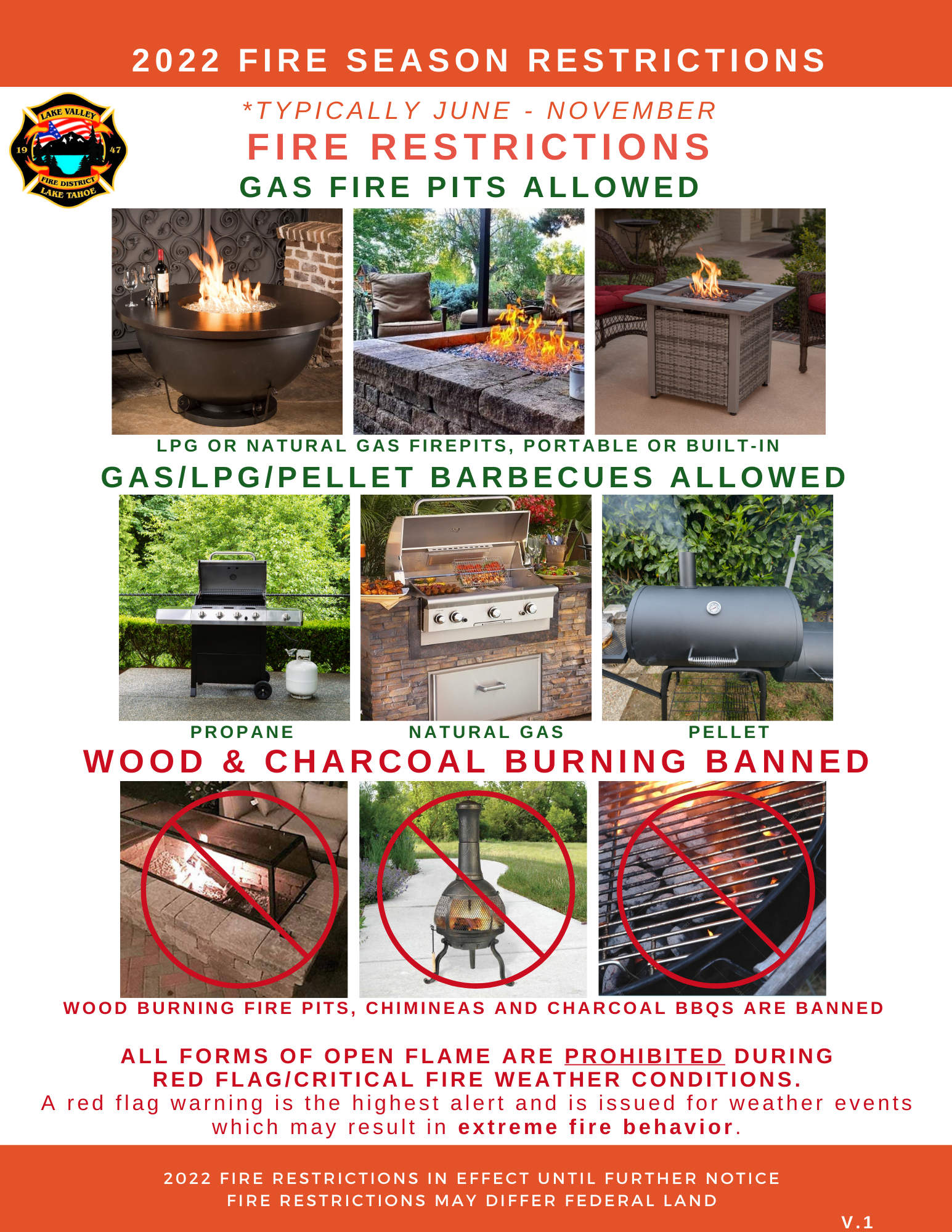
by Martin Goldberg | Jun 1, 2022 | News, Uncategorized
FIRE RESTRICTIONS
The Lake Valley Fire Protection District has activated local fire restrictions and has suspended the outdoor burning of solid fuels as of June 1, 2022. ONLY Natural Gas (NG) or Propane (LPG) outdoor fire pits and barbecues, and pellet grills/smokers are allowed. The ban remains in effect for the duration of the fire season.
Enjoy your Tahoe summer safely with family and friends and BE FIRE SAFE. For more information, contact us at (530) 577-3737.

by Martin Goldberg | Jun 23, 2022 | News
Forest Order No. 19-21-02
USDA Forest Service
Lake Tahoe Basin Management Unit
Camping and Campfire Restrictions
Pursuant to 16 U.S.C. § 551 and 36 C.F.R. § 261.50(a), and to protect natural resources, the following acts are prohibited within the Lake Tahoe Basin Management Unit. This Order is effective from June 27, 2021, through June 27, 2024.
- Camping, except in the areas described on Exhibit A for no more than 14 days in a calendar year in total, as shown on Exhibit 36 C.F.R. § 261.58(e).
- Building, maintaining, attending or using a fire, campfire, or stove fire, except within the areas listed on Exhibit B. 36 C.F.R. § 261.52(a).
Pursuant to 36 C.F.R. § 261.50(e), the following persons are exempt from this Order:
- Persons with Forest Service Permit No. FS-7700-48 (Permit for Use of Roads, Trails, or Areas Restricted by Regulation or Order), specifically exempting them from this Order.
- Persons with a valid California Campfire Permit are not exempt from the prohibitions listed above, however, persons with a valid California campfire permit may use a portable campfire pit, stove, or lantern that uses gas, kerosene, jellied petroleum or pressurized liquid fuel.
- Any Federal, State or local officer, or member of an organization rescue or fire fighting force in the performance of an official duty.
These prohibitions are in addition to the general prohibitions found in 36 C.F.R. § Part 261, Subpart A.
A violation of these prohibitions is punishable by a fine of not more than $5,000 for an individual or $10,000 for an organization, or imprisonment for not more than six months, or both.
16 U.S.C. § 551 and 18 U.S.C. §§ 3559, 3571, and 3581.
Done at South Lake Tahoe, California, this 24th day of June, 2021.
_____________________________
Gwen Sanchez
Acting Forest Supervisor
Exhibit A
Lake Tahoe Basin Management Unit
- Camp Richardson Resort and Campground
- Fallen Leaf Campground
- Bayview Campground
- Meeks Bay Campground
- Meeks Bay Resort
- Within 300 feet of the McKinney-Rubicon Springs Road (Forest Road No. 14N34), from its intersection with the Off-Highway Vehicle Staging Area, then west to its intersection with the boundary of the Tahoe National Forest.
- Buck Lake
- Kaspian Campground
- Blackwood Canyon Campground
- Watson Lake Campground
- Within 300 feet of the Tahoe Rim Trail.
- Within 300 feet of the Pacific Crest National Scenic Trail, from its intersection with the southern boundary of the Lake Tahoe Basin Management Unit, then north to its intersection with the northern boundary of the Lake Tahoe Basin Management Unit.
- Zephyr Cove Campground
- Nevada Beach Campground
- Luther Campground
- Meiss Management Area
- Mount Rose Wilderness
- Within 300 feet of Genoa Peak Road (Forest Road No. 14N32), from its intersection with White Hill Spur Road (Forest Road No. 14N32A), then south to its second intersection with Logan House Loop Road (Forest Road No.14N33).
- William Kent Campground
- Within the Desolation Wilderness with a valid Wilderness Permit.
Exhibit B
- 64 Acres Day Use Area
- Baldwin Beach Day Use Area
- Bayview Campground
- Blackwood Campground
- Berkeley Camp
- Camp Concord
- Camp Richardson Resort Campgrounds
- Camp Richardson Stables
- Camp Shelly
- Eagle Falls Picnic Area
- Fallen Leaf Campground
- Kaspian Day Use Area
- Kaspian Campground
- Kiva Picnic Area
- Luther Campground
- Meeks Bay Campground
- Meeks Bay Resort and Campground
- Nevada Beach Campground
- Nevada Beach Day Use Area
- Pope Beach Day Use Area
- Zephyr Cove Resort Campground
- Watson Lake Campground
- William Kent Campground
- William Kent Day Use Area